Some Web Central views include geospatially-enabled maps that help you visually assess your data by location. These views show sites or buildings based on the building's latitude and longitude. When a user runs a geocode action, the application derives the latitude and longitude from the building's address. An example of a view that includes geocoding is found in the Technologies / User Interface Add-Ins / Geographic Information Systems(GIS) Views / Map with Address Geocoder task.
If a map shows sites, the application chooses the location of the first building listed for the site that includes latitude/longitude data.
Map views are enabled by default, so you do not need to enter an application parameter to use them.
When working with maps, you can use your mouse to pan the map by clicking and dragging on the map. Use your mouse wheel to zoom in and out.
Each application has different needs, so the specific map features that are available vary by application. Each map has a Help topic describing how that map works, and the particular business issues the map addresses.
The following sections of this topic describe the basic map features, to help you become familiar with the benefits map views can provide.
Map views include a drill-down selection list of locations for which you have entered data. When you select a location, the map shows the data by placing color-coded markers on the map , and providing a key that describes the range for each color. For example, in the Environmental Health & Safety application, you can see the number of safety related incidents by location with the legend describing the number of incidents represented by each color. In this case, the map makes it clear if a particular facility or geographic location is experiencing an unusually high number of incidents.
In some applications, you can select the data that the marker represents and additionally set marker size to reflect the value for another parameter. For example, you can show your compliance program locations on the map, highlighting the locations by their compliance level, and showing marker size by program count, helping you assess which program locations are putting you at risk for non-compliance, and the relative number of programs involved for each compliance level.
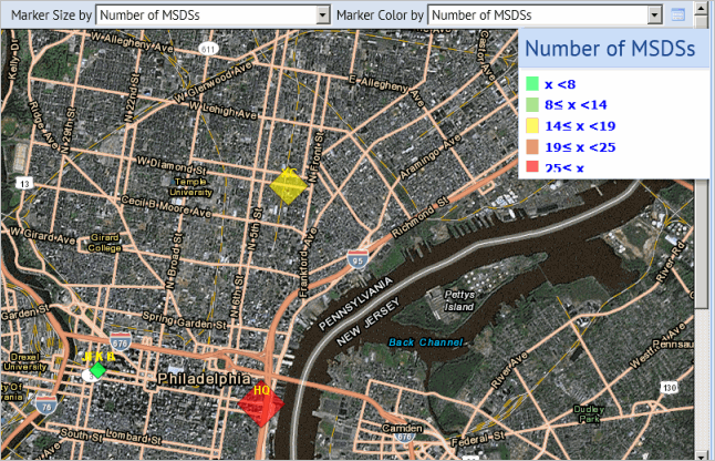
The following image shows a map from the Material Safety Data Sheets application in which the markers are color-coded and sized to reflect the number of MSDSs at each location. A legend describes the range for each color.
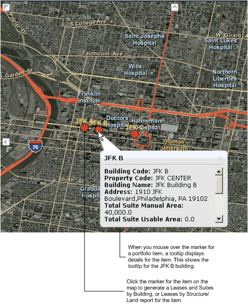
From the map you can access additional information for a location in the following ways:
The following shows a map with a tooltip, and with a description of the additional information available when you click on the marker.
| Copyright © 1984-2014, ARCHIBUS, Inc. All rights reserved. |