Many ARCHIBUS applications use the geographic hierarchy to record information about the location of physical properties or companies and organizations with which you do business.
ARCHIBUS provides tables for the following elements of a geographic hierarchy:
The geographic tables are hierarchical; that is, the higher level tables validate against fields in the lower level tables. Therefore, you will want to develop these tables in the order in which they are listed above so that the values are available to choose when completing tables lower in the hierarchy.
The purpose of the fields of the tables will be evident to you. The following are some important notes:
|
Table |
Purpose |
|---|---|
| Geographic Business Regions | For organizations doing business globally, geographic regions group your countries into the geographic regions you define. On global dashboards that include a map view, such as the Real Estate Portfolio Management's Global Portfolio Dashboard, you first select a geographic region, and can then select a country, and site to zoom the map to that location. If you are doing business in more than one country, developing geographic business regions can provide a way to summarize data for several countries. |
|
Countries Table |
If you plan on developing regions, you must develop the owning countries. |
|
Regions Table |
Regions represent geographic areas of countries and are identified by Country Code + Region Code. You must enter a country for a region. |
|
States Table |
The States table holds a country’s legal divisions, such as Canadian provinces or U.S. states. State Code is the identifying field and must be completed. |
|
Counties Table |
Counties are identified by the combination of State Code + County Code. You must enter a state for the county. |
|
Cities Table |
Cities are identified by State Code + City Code. You must enter a state for a city. |
| Sites Table |
Sites (or campuses) can hold multiple buildings. for example, an Executive Office Park site on which three office buildings are located. Note that for the Number of Buildings field, you must enter the number of buildings located on the site; the system does not calculate this value. For more information on sites, see Location Hierarchy: Sites. For certain drill-down selection lists that present locations, or for certain types of data rollup, sites are required. See the below sections, Developing Geographic Locations for Real Estate Portfolio Management and Geographic Locations and Map Views for more details. |
Use the Define Geographic Locations (the ab-sp-vw-rm-by-bl-fl.axvw view) task to enter new items in the hierarchy, or edit existing items.
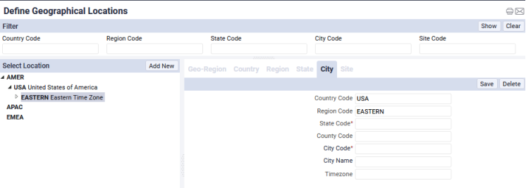
The view uses drill-down selection lists to present the levels of the hierarchy. For information on working with this, see Using Drill-Down Selection Lists. When you drill down to a selection and then add new values, the view pre-fills the form with the values of your drill-down selection. For example, you can drill down to a region and then use the Add New button to add a city: as shown in the below image, the form is pre-filled with the dril-down selection.
When editing existing data, you can use the filter console, located at the top of the view, to limit the display of the locations to only those containing the value you enter in the filter console. For information on the filter console, see Using Filter Consoles
Geo-coding building locations: Several applications include views that show your data on geospatially-enabled maps. To place locations on a map, the application uses the building's street address (Address 1 field) together with the City and State Codes to calculate the latitude and longitude for the location. For this reason, when using map views, this information is required.
The application calculates the longitude and latitude when a geocode action is run. The Real Estate Portfolio Management domain includes a geocode button on the Manage Buildings / Structure / Land by Locations maps. For the Thematic Energy Map, you can run a geocode action when assigning weather stations to buildings. For other applications, the Business Process Owner can geocode the building when adding it using the Background Data / Define Locations task. See Developing Locations (Sites, Buildings, Floors).
Additionally, the Technology Process includes examples of views that demonstrate geocoding. Your Add-In Manager can use these views to develop your own views for geocoding. For an example, see Technologies / User Interface Add-Ins / Geographic Information System (GIS) Address Geocoder.
Drill-down selection lists: Map views include a drill-down selection list that you use to select the locations for which you want to see your data. The geographic levels are Country, Region, State, City, Site, and Building. To view buildings for the Waste Management Map, Incident Maps, and Compliance Management Program and Violations maps, you should develop sites that you then associate with buildings. This provides an unbroken geographic hierarchy so that you can drill down to select the locations for which to view your data. The Thematic Energy Map requires building data, but does not require sites.
There are some special considerations when developing geographic data for use in the Real Estate Portfolio Management domain. When developing data to be used in this domain, be aware of the following:
If you do not want to track your portfolio items for all geographic levels, you can develop your data up to the level that interests you. For example, to track your portfolio to the city level, maintain data from the city down, that is city, site and building. However, if you miss a level, such as site, the application is not able to roll up your building data to the city level.
| Copyright © 1984-2019, ARCHIBUS, Inc. All rights reserved. |