For key performance indicator (KPI) charts grouped by geography, you can drill down to see data for the next level down. Drilling down enables a progressively more detailed view of your data, and can be useful when doing root cause analysis.
For example, if a chart showing your estimated area by state for the next year includes a precipitous decline in area for a particular state, you can drill down to see which city is causing the decline. You can then drill down to the site, and even the building level to examine the cause of the decline.
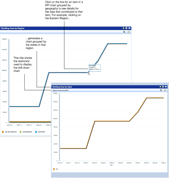
You drill down to a chart item by clicking anywhere within its bar; a pop-up window shows the chart restricted to only that item. You can continue to click items in the drill-down chart to drill down one more level. You can drill down to the single portfolio item level (building, structure, or land).
For example, if you are viewing a chart that shows your buildings by regions, and you click on a region, you view a chart showing buildings for the states in that region. Clicking a state in that chart generates a chart showing buildings for the cities in that state.
The Filter button is available from the drill-down so that you can apply filters to the drill-down chart if needed.
Note 1: Drilldown is not available for charts grouped by properties or facility type, or for the Area Availability by Location and Time chart.
Note 2: To have the portfolio item appear in all key performance indicator charts, enter all geographic locations for portfolio items: Country, Region, State, City, and Site Codes. Because geographic locations are a hierarchy, if you do not enter a geographic location for a portfolio item, you are not able to drill down to the missing geographic levels.
Note 3: For the Land Area by State KPI chart only, the drill down does not work unless you maximize the chart view. For all other charts, you can drill down from any view for the chart.
The following image shows a KPI chart for Building Area by Region with a drill -down chart showing the estimated area for states for the region that was clicked on.
| Copyright © 1984-2019, ARCHIBUS, Inc. All rights reserved. |