Environmental & Risk Management / Compliance Management / Operational Reports
Environmental & Risk Management / Compliance Management / Management Reports
Compliance Program Map
The Compliance Program Map report provides a comprehensive picture of compliance status world-wide. The report provides a map view with both a drill-down list and Filter console to enable you to restrict the view to the locations you want to review. The map includes marker symbols over locations containing compliance programs. These markers are color-coded to show areas by critical factors, such as , enabling you to quickly evaluate compliance by location and to assess areas of concern.
This report applies to both -related and -related records. The view does not include items that are Completed, Completed-Verified, or Closed.
The map enables you to get more details in the following ways:
- When you mouse-over a map marker, a tool tip provides the name of the location.
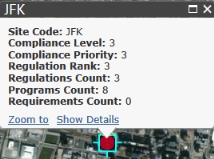
- When you click on a marker symbol, a pop-up window identifies the location, the , , Regulations Count, Compliance Programs Count, Requirements Count, and . The values for Level, Priority, and Rank are computed for the location depending on the selections for the marker symbol and filters you select as described in the following sections.
- When you click the Show Details link you can see the regulations, compliance programs, and requirements used to summarize information for that location.
Prerequisites
To view programs on the map, the following are required:
- You must develop data for the geographic hierarchy (Country, Region, State, and City). See Geographic Locations and Map Views.
- You must develop data for your buildings, including the Address 1, City, and State fields. The application requires this information to place the building on the map. You must also associate the buildings with sites. See Developing Locations.
- You must enter a site location for a program to view the program on this map. See Managing Compliance Violations.
- The locations must have programs associated with them, as the drilldown list for locations shows only locations that have programs, and locations without programs would not have any compliance status data to roll up.
How the Filter Determines the Compliance Level
When you enter a Compliance Level in the Filter, note the following:
- If there is a compliance level entered for the location, that compliance level is used.
- If there is no compliance level for the location, but there is for the requirement or contract term, this compliance level is used.
- If there is no compliance level for the location, contract term, or requirement, but there is for the program or contract, this compliance level is used.
Marker Symbol Selections
You can make the following selections for the markers symbols to control what is shown
For example, suppose you make the following selections:
- Compliance Level for Marker Color by
- Lowest Value for Marker Color Method
- 20 % for the Minimum Threshold
- Programs for Locations For
- County for Locations
Suppose also that there are 10 programs that match the Filter at a particular County, that only one program has a Compliance Level of "0", and two programs have a Compliance Level of "1." In this case, the Compliance Level of the county would be "1" because Level "0" represents only 10% of the programs in the county that match the Filter. Since 10% is below the threshold of 20%, Level "1" is used.
| Copyright © 1984-2020, Archibus, Inc. All rights reserved.
|